One of the smoother sections of gravel road
 A view of the road with the pipeline snaking through the wilderness beside it . . . we followed the pipeline for hundreds of miles.
 Some of the scenery along the way
 A little pond we happened upon along the road . . . gorgeous and peaceful!
 Joanne in front of the pond
 Trying out the new tripod we bought and the timer on the camera
 The first view of the Yukon River
 The Yukon River from the bridge. The Yukon River Camp is the first stop for services on the Dalton Highway, but we didn't stop since we had a full gas tank when we left.
 Dalton Highway or "Haul Road"
 A field of wildflowers
 The wilderness just stretches for miles and miles, as far as we could see
 "Finger Mountain," a landmark for years and years
 Terrain around Finger Mountain
 A panoramic shot of the terrain
 Dalton Highway and the pipeline headed north
 Made it to the Arctic Circle!
 By the time we got to the Arctic Circle, we had decided we would either have to go on to Coldfoot, 60 miles north, for fuel, or go back to Yukon Camp for fuel. But Yukon didn't have a campground there or south of there until almost Fairbanks. So we decided to go see what Coldfoot was like, since they had a campground.
One of the first views of the Brooks Mountain Range, which runs east to west across Alaska
 Some more views on the way to Coldfoot
 A view of the Trans Alaskan Pipeline winding its way through Alaska 's wilderness
 Grayling Lake
We arrived in Coldfoot between 9 and 10 pm, fueled up (at $4.50/gal.!) and ate dinner in the restaurant there. Coldfoot was originally a gold-mining camp and made a resurgence as a camp for pipeline construction crews. Now it's a service stop on the Dalton Highway, catering mostly to truckers driving the highway to supply the oil industry at Prudhoe Bay. While waiting we talked with some other travelers . . . a woman and her friend and their kids who we had seen earlier at a few pull-offs along the way. It turns out that a few years ago, before she had kids, she had worked as a tour guide taking groups from Fairbanks to Deadhorse and Prudhoe Bay. When we told her we planned to return to Fairbanks the next day, she said, "Oh, no, you have to at least go on to Atigun Pass; that's the most beautiful scenery of the trip!" She also told us we'd be much more likely to see wildlife there. So we studied the map and decided to take her advice and go that far the next day.
View from our campsite at Coldfoot Camp just before we went to bed at 11:30
 The truck in front of the restaurant in Coldfoot Wednesday morning before we left. Ernie had decided by this time that we should not only take the tour guide's advice and drive on to the Atigun Pass, but since we were that far into it, we might as well go all the way to Deadhorse on Prudhoe Bay! I wasn't 100 percent convinced that was a good idea, but we were so close and would never have another chance to drive as far north in Alaska as possible. So off we went to continue our adventure! I made some sandwiches to eat for lunch
on the way, since we knew there were no services anywhere before Deadhorse--240 miles away!

After leaving the Coldfoot Camp, we went across the road to visit the Arctic Interagency Visitor Center, a beautiful facility run by the Bureau of Land Management, US Fish and Wildlife Service, and National Park Service . . . extremely informative about the Arctic region of Alaska. They even have a summer volunteer from Anderson--student at Ball State--but she wasn't there that day :( They loan out binoculars, so we borrowed a pair for our trip north since we had sadly forgotten to take ours.
The tour guide lady had told us about the village of Wiseman north of Coldfoot, a few miles off the highway and one of her favorite spots . . . in fact, she loved it so much, she chose to get married there. So we decided to take her advice and check it out. It's pretty much out in the wilderness and not much there, but on a river in a beautiful setting. The Boreal Lodge was the only obvious place of business, with a lodge and gift shop. When we drove up, we spotted two labs lying in front, who immediately jumped up to greet us. The black lab grabbed a stick and ran toward us, and the white lab grabbed a ball and was obviously eager to play! I just had to laugh . . . they reminded me so much of Carter, Jesse and Amber's lab! The white one, Reload, is just begging Ernie to play ball with him!
 Reload and Bogie in front of their Boreal Lodge in Wiseman
 The gates to Boreal Lodge in Wiseman
 Sukakpak Mountain as we drove into the Brooks Mountain Range
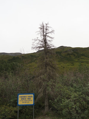
 The last spruce tree along the northbound Dalton Highway, which was killed by vandals in 2003 but is still standing. The terrain changes in this area. . . few trees of any kind
 Driving into the Brooks Mountain Range
 A good view of the Brooks Mountains with the hovering clouds, the pipeline, and the road
 Approaching the Atigun pass with snow on the windshield. The Atigun Pass is the highest highway pass in Alaska and the Continental Divide, dividing rivers running north to the Arctic Ocean and south to the Pacific Ocean
 The road up the mountain
 A musk ox on the side of the mountain--too far away to get a good shot. With the binoculars he was quite impressive!
 An example of the condition of the road much of the time
 We arrived in Deadhorse a little after 11:00 pm. At that location, the sun never sets between May 13 and August 13, so it still seemed like daylight to us. But there wasn't too much activity at that time of night, so we didn't feel like we were in the way when driving around looking at the sights. My impression of Deadhorse was that it looked like dozens of construction sites in one place--all the buildings are the metal buildings that are usually on construction sites, lots of trucks and lots of machinery. It all looks very industrial--everything there supports the oil fields and industry. We couldn't drive out to Prudhoe Bay, where the oil fields are--individuals aren't permitted beyond Deadhorse, which is about 7-8 miles from Prudhoe Bay and the Arctic Ocean. The only way to go is with a commercial tour group, and we didn't really want to do that, so we settled for going as far as Deadhorse and seeing as much there as we could.
A few sights around Deadhorse . . .


 We gassed up at a self-service gas pump, one of only two places to get gas there, and located the "campground." The only camping permitted in Deadhorse is in the parking lot of the Arctic Caribou Inn--which is not like any hotel I've ever seen before--or any campground, either! There were no hook-ups, no services--we could use the restroom inside, but that was about it. So about midnight we set up the camper, ate the remainder of our sandwiches we hadn't finished at lunch, and tried to get some sleep after a very long, hard day!
 See "Arctic Circle Adventure Part 2" for the return trip back to Fairbanks.
 Reload and Bogie in front of their Boreal Lodge in Wiseman
 The gates to Boreal Lodge in Wiseman
 Sukakpak Mountain as we drove into the Brooks Mountain Range
 The last spruce tree along the northbound Dalton Highway, which was killed by vandals in 2003 but is still standing. The terrain changes in this area. . . few trees of any kind
 Driving into the Brooks Mountain Range
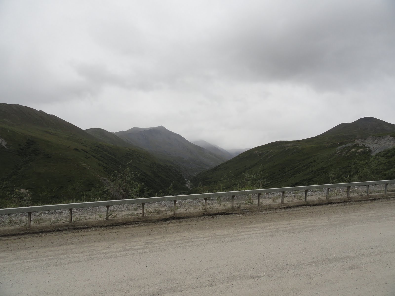 A good view of the Brooks Mountains with the hovering clouds, the pipeline, and the road
 Approaching the Atigun pass with snow on the windshield. The Atigun Pass is the highest highway pass in Alaska and the Continental Divide, dividing rivers running north to the Arctic Ocean and south to the Pacific Ocean
 The road up the mountain
 A musk ox on the side of the mountain--too far away to get a good shot. With the binoculars he was quite impressive!
 An example of the condition of the road much of the time
 We arrived in Deadhorse a little after 11:00 pm. At that location, the sun never sets between May 13 and August 13, so it still seemed like daylight to us. But there wasn't too much activity at that time of night, so we didn't feel like we were in the way when driving around looking at the sights. My impression of Deadhorse was that it looked like dozens of construction sites in one place--all the buildings are the metal buildings that are usually on construction sites, lots of trucks and lots of machinery. It all looks very industrial--everything there supports the oil fields and industry. We couldn't drive out to Prudhoe Bay, where the oil fields are--individuals aren't permitted beyond Deadhorse, which is about 7-8 miles from Prudhoe Bay and the Arctic Ocean. The only way to go is with a commercial tour group, and we didn't really want to do that, so we settled for going as far as Deadhorse and seeing as much there as we could.
A few sights around Deadhorse . . .


 We gassed up at a self-service gas pump, one of only two places to get gas there, and located the "campground." The only camping permitted in Deadhorse is in the parking lot of the Arctic Caribou Inn--which is not like any hotel I've ever seen before--or any campground, either! There were no hook-ups, no services--we could use the restroom inside, but that was about it. So about midnight we set up the camper, ate the remainder of our sandwiches we hadn't finished at lunch, and tried to get some sleep after a very long, hard day!
 See "Arctic Circle Adventure Part 2" for the return trip back to Fairbanks.
No comments:
Post a Comment