At a stop for gas, restroom, and refreshment, we discovered from a local Alaskan that behind a quarter mile row of trees along the road were acres of farm fields. Ernie had commented earlier that all of Alaska's food must be shipped in because he had not seen any farm fields, tractors, etc. Later we did find some agriculture around Palmer, but near Delta Junction we found more! Roads were gravel and pretty rough, but the old farm boy had no trouble navigating them and enjoying the farm scenery!
A hay field with bales of hay

South of Delta Junction we drove through some gorgeous mountain scenery! Glad we didn't miss this--it was worth the extra driving, even with some clouds moving in!


Alaska Pipeline again . . . we followed the Alaska Pipeline all the way from Deadhorse, near its origin, to Valdez (broken up at different times).

A panorama of some of the beautiful scenery

Delta River floodplain, where a herd of wild bison can often be seen grazing. We didn't see them though.

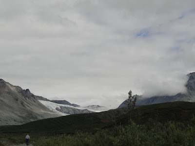
Glaciers on the distant mountains

We camped at Fielding Lake State Recreation Area beside a lake, above the tree line.

Fielding Lake, behind our campsite


From a wayside along the highway, we saw a road below that led close to a glacier. So Ernie the Adventurer decided he needed to check it out, while I kept saying, "Are you sure we should be here?" It didn't look like a road to me! Milepost described it as an abandoned pipeline road, the drive down into the valley was very steep, and the road was very rough! But off we went to explore . . .

Ernie walking along the path closer to the glacier after the road seemed to end

Fog around the top of the mountain and glacier

Panorama of the area

Close-up of the glacier

We could hear the sound of water but couldn't see it until we walked a little farther over a hill and found the glacier-fed stream.

After getting back on the highway, we passed Summit Lake.

Paxson Lake, where we camped previously after driving the Denali Highway from Cantwell to Paxson--with blue skies this time! When we camped there earlier, it rained all night and all morning. We had now completed the last leg of the Richardson Hwy., completing our drive of all the major Alaskan roads.

No comments:
Post a Comment